Port Said
| Port Said | |||
|---|---|---|---|
|
|||
 |
|||
 Port Said
|
|||
| Coordinates: | |||
| Country | |||
| Governorate | Port Said Governorate | ||
| Population (2001) | |||
| - Total | 515,007 | ||
| Time zone | EST (UTC+2) | ||
| - Summer (DST) | +3 (UTC) | ||
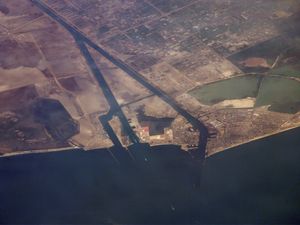
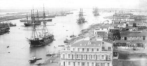
Port Said (Arabic بورسعيد transliterated Būr Saʻīd) is a city in north-east Egypt, near the Suez Canal, with an approximate population of 515,007 (2001). The city was established in 1859 during the building of the Suez Canal.
The economic base of Port Said is fishing and industries, like chemicals, processed food, and cigarettes. Port Said is also an important harbour both for exports of Egyptian products like cotton and rice, but also a fueling station for ships that pass through the Suez Canal. Port Said also thrives on being a duty-free port, as well as a summer resort for Egyptians.
There are numerous old houses with grand balconies on all floors, giving the city a distinctive look. Port Said's twin city is Port Fouad, which lies on the eastern side of the canal. The two cities coexist, to the extent that there hardly is any town centre in Port Fouad. The cities are connected by free ferries running all through the day, and together they form a metropolitan area with over a million residents.
The diocese of Port-Said for the Coptic Orthodox Church was founded in 1976 by his grace Bishop Tadros. In 1993, the late subdeacon Nosshy Attia Anbary wrote the history of the diocese in Arabic.
In addition to its port, the city is served by Port Said Airport.
Both in the Suez Crisis (1956) and in the Yom Kippur War (1973) Port Said was heavily demolished.
Contents |
The port
The port is bordered, seaward, by an imaginary line from the western breakwater boundary till the eastern breakwater end. And from the Suez Canal area, it is bordered by an imaginary line extending transversely from the southern bank of the Canal connected to Manzala Lake, and the railways arcade livestock.
- Main Channel
- Length: 8 km (5 mi)
- Depth: 13.72 m (45.01 ft)
- East Verge Channel
- Length: 19.5 km (12 mi)
- Depth: 18.29 m (60.01 ft)
Approach Area
Two breakwaters protect the port entrance channel: the western breakwater is about 3.5 miles (5.6 km) long, and the eastern breakwater is approximately 1.5 miles (2.4 km).
Dwelling Area
The Suez Canal dwelling area is situated between latitudes 31° 21' N and 31° 25' N and longitudes 32° 16.2°' E and 32° 20.6' E. where vessels awaiting to accede Port Said port stay whether to join the North convoy to transit the Suez Canal to carry out stevedoring operations or to be supplied with provisions and bunkers. The dwelling area is divided into two sections:
The Northern Area is allocated for vessels with deep drafts. The Southern Area is for all vessel types.
Sister cities
Notable natives
- Hans Dijkstal, Dutch politician (former Deputy Prime Minister)
- Mohamed Shawky, professional football player with Kayserispor
- Mohamed Zidan, professional football player with Borussia Dortmund
Climate
Port Said has a Mediterranean climate, with moderate summers and winters. The city witnesses average rainfall during winters. Sleet and hail are also common.
| Climate data for Port Said | |||||||||||||
|---|---|---|---|---|---|---|---|---|---|---|---|---|---|
| Month | Jan | Feb | Mar | Apr | May | Jun | Jul | Aug | Sep | Oct | Nov | Dec | Year |
| Source: Climate Charts [1] | |||||||||||||
Port Said City Image gallery
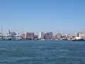 Port Said coastline |
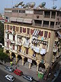 The unique type of houses in Port Said making use of Arches |
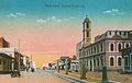 Port Said (postcard around 1915) |
 |
See also
- Port Said Governorate
References
- ↑ "Port Said/El Gamil, Egypt: Climate, Global Warming, and Daylight Charts and Data". Climate Charts. http://www.climate-charts.com/Locations/u/UB62332.php. Retrieved September 11, 2009.
External links
|
|||||
|
||||||||||||||||||||||||